A Detailed Journey Northbound on the Oregon Section of the Pacific Crest Trail
This is a 3 part series where I documented backpacking the Oregon section of the Pacific Crest Trail. I took notes of each day’s adventures in a small notebook at night in my tent, and packed 4 disposable film cameras along to carry along the way. The day notes are recorded exactly as I had written them in the notebook, so it’s fun to see the progression over time.
In the end, the trip spanned 33 days, with a little over 500 miles traveled on foot.

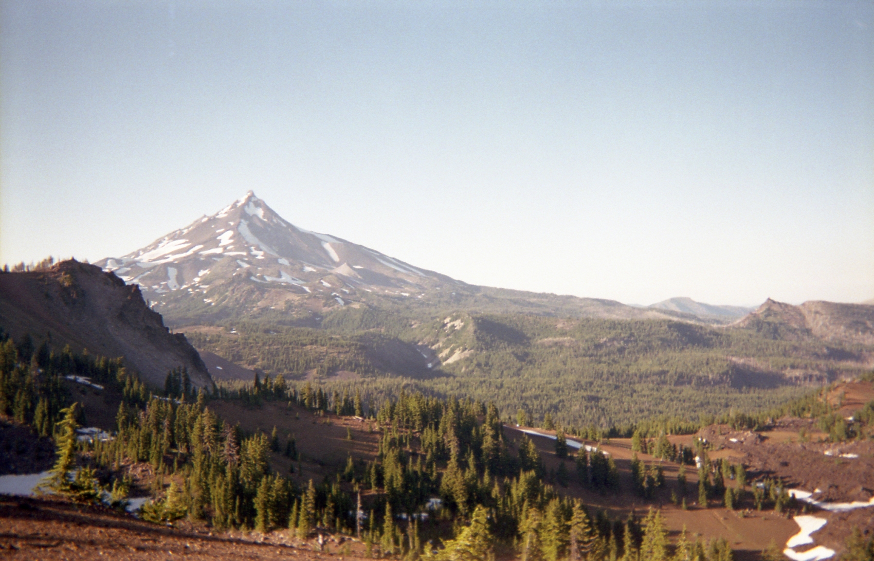
The trek from the OR/CA border to Crater Lake on the #PCT
Unfortunately without any cell service in Mazama village (Crater Lake area), I had to save this for when I’m near a random cell tower.
As of now, Scott and I have hiked over 130 miles, which is slightly more than a quarter of Oregon. We’re learning ways to save weight along the trail and finding out what foods we really crave (like vegetables). The Guayaki Yerba mate has turned out to be worth every ounce. The stuff steeps in cold water for gosh sakes! So convenient. The footwear situation is also really interesting. I initially thought that a good pair of boots was the answer, but I’ve barely worn them at all. It turns out these little Danner Soho low tops are tough as hell and have seen most of the mileage (over 100 so far). Another note: showers are a beautiful thing after days of sweating and bug spray.
Day 1 – While unloading our gear from the car, we notice that Scotty’s water had all leaked out of his Camelpack, and so he started the trail dry. It was about noon when we left from the Oregon/California border. Our packs were at their heaviest with all of our food and water. Almost immediately run into and meet Evan (16) and his dad who had started three days ago. They pass us, and we begin the hike around 6300 ft. Throughout the partially rainy day, we crossed snow, rocky terrain, and went up and down mountains. The day ends after about 9 miles and we fall asleep to Willie Nelson.
Day 2 – With Callahan’s lodge as our final destination for the day, we had no reason to stop until we got there. My pack is feeling heavy and I’m already debating what to mail home. We met some cool people along the way that were interested in what we were doing. While on the trail we got passed by a guy that we would later find out to be named Zeke. When we finally got to Callahan’s (20 miles later) we ran into him and talked about the trail. Getting to Callahan’s was a story in itself because we missed the special trail that goes directly to the lodge. We ended up running across both highway 99 and I5 to get to the lodge. Anyways, the bartender at Callahan’s said that we get a free beer for coming, so we talked trail over some drinks. At the end of the night, I gave Zeke some Guayaki Yerba mate and we went to sleep in our tents in Callahan’s back yard.
Day 3 – After originally planning on taking it easy and letting our blisters heal, we decided to keep moving. We got free coffee and OJ from the owner of Callahan’s in the morning, and he gave us a ride to the trailhead. About 5 minutes after getting dropped off at the tailhead, I realized that I had forgotten my phone at the lodge. So I called the receptionist and told her to give it to Zeke, because I knew he would pass us on the trail (he was doing about 30 miles a day). Sure enough he met up with us a few hours later and dropped off my phone. I took his portrait when he passed us. We only made it about 12 miles, and stayed the night at Hobart’s Bluff.
Day 4 – We left from Hobart’s Bluff with the intention of getting to Hyatt Lake. Along the way, we met up with a guy named Plant, and he told us about SoCal and the perks of doing the whole trail. He had stories about trail magic where strangers would invite hikers into their homes for days to feed them and spoil them before releasing them back into the wild. Anyways, when we got to Hyatt Lake, the ranger, Libby, showed us where to stash our bags while she took us to the best restaurant in the area. We went to Greenspring’s Inn, where we shared a pitcher of beer and enjoyed a fresh meal. Once the locals found out that we were PCT hikers, they gave us each a free glass of wine. While looking for a ride back to the campground, we randomly started talking to a guy about beer. It turns out that he was the brewmaster for Southern Oregon Brewing. He gave us tastes of his favorites, offered us a ride home, and gave us each a 22 for back at the campground. Talk about trail magic.
Day 5 – Slept in until about 10. After coming in late the night before, we woke up to find out that we had camped in the handicapped section. As we packed up, scott realized that he didn’t have his wallet. After searching helplessly, he realized that he must have left it at the Inn. As we started walking back to the road, thinking about looking for a ride for the 3 miles to Greenspring’s Inn, we ran into a lady on a horse. The conversation started over her asking where we had come from. We told her our story, and it turns out that she was raised in a similar part of town as us. She said that her husband would definitely give us a ride to the Inn and called him that moment. He showed up 5 minutes later and gave us the lift. After all that was over we finally hit the trail at 12:30 pm. We only made it about 12.5 miles, but camped right next to a spring just south of Brown Mountain Cabin.
Day 6 – Started early today around 7 am to get on the trail hard. Leaving the forested area, we entered a lava rock area (which was painful walking over). The day ended at Fish Lake Resort, which put us at 19.5 miles on the day. Fish Lake wasn’t nearly as nice as Greenspring’s, but the people were nice and the food was needed. Scott thinks he tore his left meniscus and my right Achilles tendon isn’t feeling so hot. Our bodies are hurting and we’re ready for bed. G’night.
Day 7 – Got a pretty late start today because Scott wanted to get a hot b-fast and some snacks from the store. Hiked for 8 hours today and put in 18 miles. Our pace is getting faster. We’ve been drinking Yerba mate every morning to get us going and it’s the perfect remedy to start to a morning. While on the trail today we ran into a guy named Caveman who was doing the entire PCT. Starting to get used to this wilderness thing. Went to bed early because the mosquitos were so bad.
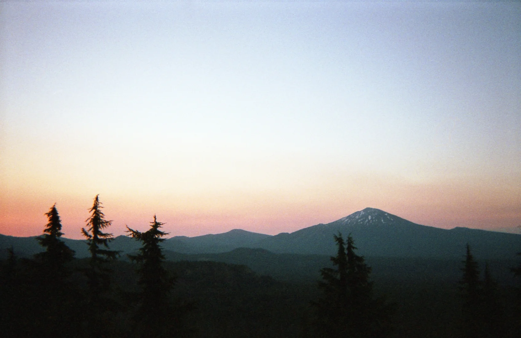
Day 8 – After hearing wolves and bears last night, it was nice to wake up in one piece. Today’s plan was to make it 25 miles, but after making a wrong turn down the “Divide Trail”, we were completely thrown off. Also dehydrated and out of water at this point, we hung out by the water source for about an hour and drank our bodies back into shape. A few mountain climbs and glacier passes later, we decided to call it an early night next to a little creek. At about 6300 ft, it was time for a hot meal. The amount of uphill today was insane. We would descend mountains just to climb them again. In the end, it was all worth it because our campground was on a mountain with a panoramic view overlooking distant mountain ranges silhouetted by the sunset. This view can be seen from inside our tents. It looked like Instagram out there. This is Oregon.
Day 9 – With no smartphone or map of any kind to get us to Mazama (Crater Lake), we faced the trail blindly. We woke up at 5:10 am and were hiking by 6 am. Without a clue of where the water sources were we began with only the water left over from the previous night. After about 12 morning miles of old forest that had seen a few fires, we came across Jack Springs. It was a half of a mile off of the trail, so we dropped our packs and brought our water bottles. The spring turned out to be more of just a puddle, but it was still delicious and needed. The hike towards Mazama continued through swarms of mosquitos and what seemed like a never ending trail. We finally got to a highway and saw a sign pointing towards the campground. After making a few wrong turns and going about 2-3 miles out of the way, we came to another road. Supposedly Mazama was only 1/10 of a mile away, but we couldn’t see it in any direction. We flagged down a driver who told us that he thinks it’s about 4 miles away. Battered and thirsty, we were over it. Scott started to climb down to get some water when the same guy came back around the corner and told us that we were almost to the campground and offered us a ride. We took it, and he brought us to the general store to get our packages. Here we ran into Caveman again, caught up, and booked a campsite. With fresh stove fuel in the package, we burned through an old canister and ate a hot meal while drinking some beers. Finally getting a chance to charge the phone, we did the math and found out that we had hiked 28.2 miles! This was up and down mountains (multiple times over 6600 ft), in the heat and over snow, with 35 lbs on our backs. What a day.
Day 10 – We slept in, relaxed, made a to-do list, and checked off the tasks. Everything that we planned got taken care of, including popping the Mount St Helen’s size blister on my foot. Today was a nice change, but we’re back on the trail tomorrow. Cheers.
Here are some pictures from our travels.


The journey from Crater Lake to Elk Lake on the #PCT
As of this point in the trip, we have backpacked over 260 trail miles on the Pacific Crest Trail. This section was filled with scorching sun, mosquito infested lakes, and snowy glacier climbs.
Day 11 – We got to sleep in today because our plan was to go to Rim Village and hang out by Crater Lake for the day. After packing up our camp, we started to walk towards the trail when the trolley driver pulled up to us and asked if we wanted a ride to Rim Village. With a blister the size of a 50 cent piece (we call it Mt. Saint Helens) on my left foot, we gratefully took the ride (it normally costs $25). Up at the village, I met a guy by the name of Side-route by the lodge. He told me that his partner and him were also doing an Oregon section of the trail. We waited around for lunch at the lodge and charged our phones, before hitting the trail. After checking the maps, we realized that the next reliable water source was in 24 miles. Instead of pushing our limits around noon, we decided to set camp at Lightning Springs, only a mile from Rim Village. We ended up meeting up with Side-route and his partner LB at Lightning Springs and sharing stories and talking about injuries by the fire. Since my right Achilles tendon was so swollen today, they gave me some first aid advice and some bits and pieces of gear that they didn’t need. We exchanged info so we can all get a beer in Portland after we’re done. I gave him some mate for the trail, and we called it a night.
Day 12 – Woke up around 5 am to get an early start. We ended up climbing all day and into the beginning of the night. The mosquitos were awful, so we didn’t worry about cooking a warm meal. Ate dry food all day and made it about 18 miles by 7 pm. Since we were on the side of Mt. Thielsen, we found a semi-flat break in the snow and set up camp. I woke up in the middle of the night to the sound of a mud slide.
Day 13 – Barely slept last night. Kept hearing noises all night. After waking up, we climbed for most of the morning, knowing that we had to get to Thielsen Creek in order to refill and hydrate. At one point we accidentally got off trail and started summiting Mt. Thielsen. We made it to about 8000 feet before realizing we were going the wrong way, but the view was worth it all. After a few more miles, we got to the creek and binged in the fresh mountain water. Took a short food break here as well and relaxed by the water. Once we for back on the trail, the climbing continued and we eventually reached the highest point in Oregon and Washington on the PCT @ 7560 feet. We began coming back down the mountain and ended up camping in a site that was on the trail. Exhausted and ready to sleep, we called it a night at 6:30 pm.
Day 14 – We started the morning with tons of uphill. We’re realizing that there’s no way to ever do anything cool without tons of uphill. We found Six Horse Spring at 7:30 am surrounded by swarms of mosquitoes, and filled up our bottles. With a plan to get to Summit Lake by nightfall, we began the journey. Unfortunately, we only made it about 18 miles before my foot started to really bother me and we had to stop. The mosquitoes swarmed us almost immediately and we had to jump into our tents right away (@ 6:30pm) just to avoid getting eaten up.
Day 15 – We woke up at 5:15 am and were on the trail by 6 am. Stopped by Summit Lake to fill up with water and began to climb. We climbed and climbed all day, up snow and through the mountains. After hours of climbing through snow, we found some glacier melt and decided to take a siesta. After a few hours of solid napping, we picked a camp spot and decided to end our day in the same spot. Near water and on flat ground, we couldn’t ask for much else. We had a fire, cooked some warm meals, and filled up with water to prepare for the morning. Went to bed at 7:35 pm. Today marks two weeks on the trail.
Day 16 – Today was pretty easy, mostly flat and downhill to Lower Rosary Lake. We actually liked it so much that we hung out by/in it for 5 hours and drank chai and chocolate mate the whole time. We met some older folk who had hiked a lot if Oregon, but were envious of our trip. After getting the motivation to leave, we made it a few miles up the mountain to call it a night at Maiden Peak Shelter. It’s a shelter for cross-country skiers in the winter, but open to hikers in the summer. It had a table, chairs, wood stove, tons of firewood, free bin, and a loft for sleeping. We made a fire to heat up the cabin, and kept it going most of the night.
Day 17 – Woke up this morning to instant coffee and started the morning with a caffeine high. We got 10 miles by 10 am and took a break at Charlton Lake. With fresh water, we had Brahma Lake in our sights for the next stop for water, in 10 miles. We ended up never finding Brahma Lake, but stopping at a small clear pond for water. Hiked about 26 miles today. Ready for Elk Lake.
Day 18 – Since we hiked so far yesterday, we only had to do about 15 miles to get to Elk Lake Resort. Around 10 am we got passed by a thru hiker named BASA who said he would be hanging at the lodge, and that he’ll see us there. Pulling in around 1 pm, we quickly got a seat at the restaurant and dove into the menu. We met up with BASA and talked stories. He’s a 52 y/o retired fireman who’s doing the entire trail from Mexico to Canada. He had to leave after a few hours to get back on the trail, so we wished him the best and he was on his way. Instead of paying for camping at Elk Lake, we crossed the street and set up our tents in the National Wilderness area. We packed up our food that we had sent ourselves, raided the free box, and then met a hiker who was on his way back to the trail. His name was Hobbler. We had heard about Hobbler from Plant and a few others. He was a free-spirited adventure-seeker who customized most of his gear, and would spend days hiking side-routes instead of normal trail miles. He was on his way to the base of the Sisters to set up base camp and summit them the next day, so we let him go after talking trail for about 20. It sounds like we may have a ride into Bend tomorrow to run errands. The trail magic is all around us.
Day 19 – Slept in. Went to Elk Lake Lodge around 8 am for the free wi-fi and was greeted with a breakfast buffet. Called my mom and Megan in the morning to talk about the trail and catch up. We got our ride confirmed for going into Bend around 5 pm. Elk Lake started to fill up with runners for the Cascade Lakes run, and it was packed full of people. As the afternoon rolled around, a music group began to do their sound check and we met the family and friends of the group by proximity. They happened to be sitting right next to us and were interested in what we were doing on the trail. One woman in particular, Nicolette (the drummer’s wife), was so interested by the adventure that she bought us each a beer. As we talked more, we discovered that she has a dream of someday doing the trail too. She kept us hydrated (with IPAs) as the band played and made sure that we always had at least one beer in hand. Her drummer husband is also a doctor (talk about multi-talented), and she offered him up to take a look at my Achilles during their break. Unfortunately we had to get going before long, so I couldn’t take her up on it, but talk about hospitality! We got our ride into Bend by a family friend of Scotty’s. Rick and (host) Scott gave us a shower, BBQ steak & veggies, coconut rice, and a couch to sleep on. Perfection.
Day 20 – Slept so well. Woke up to clean laundry, real coffee, music, sunshine, another shower, and breakfast. We went to a yoga class at 11am to get our stretch on, and then ran errands the rest of the day. Had a few strawberry daiquiris with more BBQ tonight, ready to get back on the trail tomorrow. It was a nice halfway vacation, but now it’s time to finish off the remaining 240 miles! Whew.
So far into the trip (2.5 weeks) I have lost 11 pounds. Pretty outrageous for how much I eat out here. It’s crazy how fast the body adapts to a situation.
Due to my phone battery dying, this section doesn’t have any digital photos, but has film photos instead.


Forest Fires, Power lines, and the Bridge of the Gods — Part 3, the voyage home
Well here it is. The final post from my journals for our trip through Oregon. It’s a long one because it covers 2 weeks of travel. Read up and indulge yourself in the adventure.
Day 21 – We ran some morning last minute errands before getting dropped off at the trail head near Elk Lake around 2pm. We hiked 4 miles up the trail when the weirdest thing started happening. I thought I had heard a lot of airplanes in the area, when we stopped to look at the sky. The same airplane had been circling us for about 20-30 minutes and dropping red and white ribbons. Having no idea what this meant, Scott called 911 and asked if it means something. The operator, Robyn, told him that the plane was testing the direction of the wind, and that we had to go back to Elk Lake to be safe from an upcoming forest fire. What a bummer right? As we were debating on whether or not we would follow her advice, another hiker walked up to us. This was Mousetrap. Mousetrap was also confused, and bummed to hear about having to turn around. He decided to call the fire dispatcher, who told him that the trail was unaffected by any fires, and to have a nice trip. So Mousetrap kept on. Confused by the conflicting information, I called 911, was transferred to fire dispatch, and was told that everything is fine and that I should have a nice trip. After wasting all that time, we decided to just camp where we were. Moral of the story: If your 911 operator is named Robyn, hang up and call again.
Day 22 – Woke up and hiked through snow, over lava beds, and through the Sister’s Wilderness area. The mosquitoes were awful this morning around Sister’s Mirror Lake. Put 20 miles in today, with the plans to make it to Big Lake Youth Camp tomorrow afternoon. Luckily, there was water all along the way today, so we were plenty hydrated and were able to have a hot linner (lunch/dinner). Noticing that there are no mosquitoes in the air where we’re going to bed. Wonderful.

Day 23 – Hiked 17 miles today through more snow and lava beds to get to Big Lake around 2 pm. The camp is a Seventh Day Adventist adventure camp with so many fun activities. Better than any camp I went to as a kid. Major plus, everyone was SUPER nice. Hikers were treated like kings. We picked up our packages, bought their dinner, which was 6 bucks of all-you-can-eat vegetarian lasagna, salad, and ice cream bars. Got a free cold shower (almost unbearable) and washed a bunch of my clothes. On the trail today we ran into a father-son combo hiking Oregon as well. We leapfrogged a few times, but saw them at Big Lake for dinner. We also met some section hikers from Portland who came into the camp at the same time as the father-son combo. These two were named Old Skool and Cheezeburger. Old Skool got his name from his love for traditional gear. He was hiking in a pair of Danner Mountain Lights! Cheezeburger just couldn’t stop dreaming about getting a beefy, juicy meal at Elk Lake when they finished their hike. Old Skool, Cheezeburger, Kingfisher (Scotty), and I (Salami) set up camp in what was called the 1st Cove. It was a beach-like setting with a bank of sand in front of the lake. We all watched the sunset disappear over the water. This was our first night of cowboy camping (no tent).

Day 24 – Woke up early to coffee and oatmeal on the beach with Old Skool and Cheezeburger. Ate camp breakfast, hydrated, and hung out charging our phones all morning. Met a thru-hiker named Scott who was doing his laundry, when Hobbler came walking in. He told us about peaking South and Middle Sister, and how he got to glissade across a few glaciers in the process. Started hiking around 2:30 pm and hiked up to Santiam Pass, where there was a water cache and a cold cherry Pepsi that we chugged. Continued to hike up Three Finger Jack through deep sand. Got about 17 miles in today and camping near the top of Three Fingered Jack. My right foot is swelling up again, but I’ll be fine. Early start tomorrow.


Day 25 – Slept in a little this morning until 6:30 am, and started hiking over Three Finger Jack. Got to Rockpile Lake for water and took a siesta. It was a nice 3 hour nap followed up with some hot mate. We kept hiking onward and ran into a guy on the trail who said that Shale Lake is beautiful and a perfect place to set up camp. On our way, we got sidetracked down a random trail a few miles and had to backtrack those few miles back uphill. Nighttime was approaching, so we decided to set up camp just off the trail and get up early to hike in tomorrow.

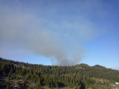
Day 26 – Hiked for about 3 hours before we ran into Hobbler again. He was just getting up around 9:30 am. We hiked most of the day through Jefferson Park. When we were taking a water/snack break, a woman on a horse told me that there is a fire on the other side of a ridge that we have to cross, and that it is spreading this way. Intimidated by another fire, we all talked it out and decided to go look for ourselves. We started to climb up the ridge, and when we got to the top, we could see smoke coming from a specific area. The fire was definitely close because there were ashes in the air and it was noticeably hotter where we were standing. Luckily, I had cell phone service. So I called the fire dispatcher, who told me that the closest fire to me was at Potato Butte, 12 miles northwest of where I was. I told him that I can see smoke coming from about a mile away, but he said that it’s just lingering smoke. Still debating whether or not to give it a go, we ran into a guy with a dog who told us that he had just climbed the summit, could see the fire, and said it was easily passable. We decided to keep going. When we got to the top of Jefferson Park, at 7010 ft, we could see the fire about 1/2 of a mile away from us. Even though there was a perfect camping spot, we decided to keep on moving. As we hiked, the wind was blowing in our direction, and the fire continued to grow in size to the point where we could see flames engulfing trees. We hiked through the sunset and the darkness to get as far away as we could. Going to bed tonight about 3-4 miles from the fire, leaving my phone on just in case. Whew.


Day 27 – Slept in because we’re alive. Hobbler hiked with us until Breitenbush Lake, where he left to hitchhike into Clackamas to go to REI. We hiked on to Olallie Lake Resort, where we ate chips, cookies, and had a few beers. We crushed our snacks and bevs and hung out by Head Lake, which was across the trail. The water was a nice temp, and so I got into the water in my hiking outfit and dried off in the sun. While here, we met some thru-hikers who all had beards: Qball, Beardoh, Wolfpack, Jeremiah Johnson, and Half Point. We also met a 65 year old Dutch section hiker named Dutchess. She said didn’t have enough fuel for her tea every morning, so I gave her one of my extras. Lightened my load, and brightened her day. We hiked on, mostly downhill, only to discover that the tent site that we wanted to camp in was taken! So we hiked on about a half mile, found a flat spot, and called it good. The mosquitoes here were nasty, so I got my tent up quickly and hopped in. Did about 18.5 miles today and are shooting for a big day tomorrow.
Day 28 – Wore my running shoes today and regretted it. There was so much dust. It got into my shoes, then into my socks, and started rubbing and creating new blisters. We got passed by the bearded thru-hikers this morning. Hiked 8.5 miles for water and ran into an older guy with his dad doing a section hike. We talked about gear by the water for a while. We continued on to the headwaters of the Clackamas River, where we got water and make a hot dinner. I actually made 2 of the meals because I was so hungry and tired of eating nuts and dried fruit. We decided to start looking for camping at this point because our bodies were sore. We camped by the river, just south of Timothy Lake. Today was about 21 miles of hiking. Not looking forward to climbing up Mt. Hood tomorrow. We have a 2000 ft elevation gain in about 2 miles up Mt. Hood to get to Timberline at the end of the day tomorrow. Planning on getting up early and wearing my Danners.

Day 29 – Today marks 4 weeks on the trail. Woke up at 5:45 am and were on the trail by 6:30. We hiked 13 miles by 11:30 am. The last 2 miles were a rough uphill, in DEEP SAND. Talk about discouraging. With every step, we would slide down a half step. It was difficult to walk normally. While struggling, I took some photos of Mt. Hood and enjoyed the lush flowers all around me. Got into Timberline around 6:30 pm after 24.5 miles on the day. Planning on doing a zero day (no miles) tomorrow. Scott’s dad is going to meet us up here and hang out. The bearded crew had gotten here this morning and were hanging out in the lodge, so we got to know them all better. Timberline has ping pong and shuffleboard, so we’re all having a good time. 47 miles left from here on out.

Day 30 – Zero day. So relaxing. Ate breakfast buffet for 2 and a half hours. Must’ve had 8,000 ish calories. Lounged. Scott’s dad showed up with fresh fruit, avocados, chips, salsa, and some chocolate, so we had a nice lunch too. He also brought some coconut water that we’re saving for tomorrow morning. Mousetrap got into Timberline, and he got a ride from Scott’s dad into Portland so he could catch his flight back to the east coast. Hung out with the beards more. Took a nap. Cooked some mashed potatoes for dinner. Went to bed in high winds that were blowing dust all over the place. So dusty.
Day 31 – Slept like a baby last night. Probably the best sleep of the trip. After packing up, we walked up to the lodge in the morning and had coffee, coconut water, and oatmeal. Hit the trail around 10:20 am and went downhill about 3500 feet, just to climb up 4500 feet. Awesome. Great views of Hood along the way. Took a side-route today to visit Ramona Falls. After only about 14 miles on the day, we found a perfect campground and couldn’t pass it up. Tomorrow we’ll do a little more than 21 miles to get to Wahtum Lake.

Day 32 – Woke up and started hiking. Saw lots of power lines and signs of civilization. Found some Salmonberries along the trail, and had some with oatmeal. Hiked about 22 miles today from somewhere random to Wahtum Lake. Did the last 7 miles without water, and chugged once I got to the lake. Getting up whenever tomorrow to hike the 13 miles to Cascade Locks. Kind of exhausted already, going to bed now at 6:30 pm.
Day 33 – Wow. That was our last night sleeping in the woods. What a trip. We woke up around 5:30 am, and were on the trail by 6. Most thru-hikers take the Eagle Creek Trail from here because it goes by Tunnel Falls, but since we’ve day hiked that tons of times, we decided to stick with the PCT. We expected lots of downhill, because that’s what the Eagle Creek Trail is. Unfortunately, the PCT is different. It was about 6 miles up rolling hills with huge climbs and huge descents, before we finally started losing the elevation for good with 7 miles of downhill. We stopped at the perfectly named Teakettle Springs for some hot mate. With the little energy kick, we finished off the trail and were excited to start seeing Cascade Locks in the distance. We followed the trail into town and kept on towards Washington. We hiked over the Bridge of the Gods and entered Washington. It was official. We started on the northern-most tip of California and crossed into Washington. This was it. 481 (official) miles and 33 days later, we made it.


We were met by my friend Ryan and my girlfriend in Cascade Locks and driven back to Portland. Time to reacclimate into society. Here’s a candid from when I first saw them. Ryan was ready with his camera…
And that’s my story. Feel free to reach out with any questions or comments. Thanks for reading!
